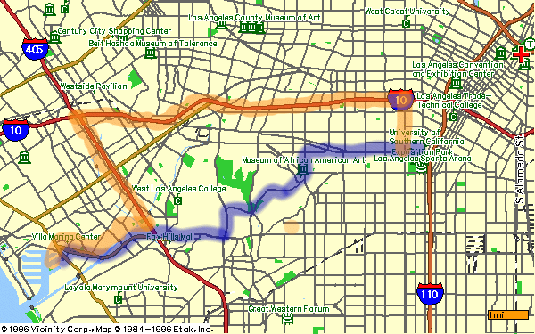
A map of USC and ISI—enjoy the retro glory that is 1996 web mapping from Vicinity and Yahoo-LA around 1996. It now links to Google Maps.
The above map shows USC and ISI: ISI is about 12 miles (20km) west of campus, near the cool and pretty Pacific ocean in Marina del Rey.
By Campus Shuttle: USC operates a “Marina del Rey Shuttle” most of the year (maybe not during winter break, though), with regular, free service from USC to ISI (and ICT). For details, see the link above.
By Public Transportation: There are several ways (consult Google maps for this or other recommendations). A fairly simple one: take the Metro E line (light rail) to the Culver City Station, then take the #7 Culver City Bus (green color), getting off at the Admiralty Way/Mininao stop, right outside ISI. Cost: a few dollars, and you will need “tap” card from the metro station (another $1), Time: about 1 hour. Or take the Metro E line (light rail) to the the Downtown Santa Monica station (the last stop), then take the #18 Big Blue Bus to the Marina/Admirality stop, a block from ISI.
By USC Shuttle: USC has a shuttle for USC students that leaves from campus and goes to ISI and Marina del Rey. Cost: free for USC students.
By Car: The above map shows two reasonable ways from USC to ISI: the easy way (in orange) and the shorter way (in blue).
The Easy Way Directions from USC: take Vermont north, (go under the Freeway and) turn left on to the Westbound 10 Freeway, take the 405 Freeway South (the exit is before the north exit), take the 90 Freeway West, turn left (south) onto Mindanao Way. ISI is the southern-most 12-story building just past Lincoln Bl.
The Shorter Way Directions from USC: take Exposition Bl. west, turn left (south, but then going basically west) onto Coliseum St., turn left (south) onto Crenshaw Bl., turn right (west) onto Stocker St., turn left (south) onto La Cienega Bl., exit right (west) onto Slauson Av., turn left (south, but then going basically west) onto the Marina Freeway (90), turn left (south) onto Mindanao Way. ISI is the southern-most 12-story building just past Lincoln Bl.
You may also be interested in parking at ISI.
See also:
